Skip to content

Quick Tasks & Search

Use this tool to quickly find a resource or task.

Master & Special Area Plans Archive

Vision 2045 Downtown Master Plan

Overview

2045 Downtown Master Plan

2045 Downtown Master Plan.jpg

On June 15, 2016, the Las Vegas City Council adopted the Vision 2045 Downtown Las Vegas Master Plan. The document replaces the Downtown Centennial Plan, which since 2000 guided the city policies and regulations and provided the envelope for urban design form within the downtown boundaries. The study area has been almost doubled, if compared to the previous plan, and the recognition of four new downtown districts now allows for the inclusion of some underserved areas that will benefit from the boundary expansion and the holistic direction for downtown. The document was built upon extensive outreach and outstanding participation from community members, stakeholders and government officials during all phases.

The plan revolves around the concept of mixed-use hubs, identified as the 10 catalytic areas for future investments, and the neighborhood centers for the 12 districts that constitute downtown. For each district the plan outlines its development needs, specific projects to be carried, a summary strategy, conceptual development yields to channel, and current and future transportation and land-use working material detailed to the parcel level. This solid base allowed the city and community to promptly start some of the projects, such as bike share, multi-modal transportation capital improvements, and a reconfiguration of the downtown trails and open space network.

Historic Westside

Implementation

The Vision 2045 Downtown Master Plan is currently in its implementation phase. View the implementation Plan presentation here.

Currently we are working on an innovative update to the zoning code for downtown, known as the Downtown Form-Based Code project. For more information on the Form-Based Code, visit www.formbasedcode.vegas

Downtown Civic Space and Trails Plan

On July 17, 2019 City Council adopted the Civic Space and Trails Plan. The plan recommends a strategy for increasing the number of parks, civic space and trails downtown. View the final plan


If you would like to speak directly with someone from the Department of Planning about this or other planning initiatives, feel free to email masterplan@lasvegasnevada.gov.

Thank you in advance for participating in the planning process, we look forward to reading your thoughtful feedback. 

Charleston

A draft plan for the Charleston area is being developed as part of the 2050 Master Plan. We want to hear from residents who live, work and visit the area outlined in the map below. This plan will guide the growth of the Charleston area and its neighborhoods for the next 25 years.

Map-2.jpg
 
The work builds on the Las Vegas 2050 Master Plan. It will focus on the five guiding principles from this plan to create a community that is equitable, resilient, healthy, livable and innovative. The plan will address a wide range of topics, including priorities and investments for:
  • Housing and development
  • Parks and open space
  • Amenities, such as playgrounds or recreation centers
  • Transit, sidewalks and bike lanes
  • Jobs and education facilities

The plan will help the city prepare for proposed upgrades on Charleston Boulevard, including dedicated bus lanes, bike infrastructure, widened sidewalks, enhanced transit station areas and other streetscape improvements, such as lighting, trees, signage accessible crossings.

Public Engagement

The final round of public engagement on the draft Charleston Area Plan has begun. This survey (English / Spanish) invites you to give feedback on any component of the plan. The survey will take approximately 5-10 minutes and focuses on the proposed vision for each chapter of the draft area plan. For detailed policies and actions, please download the draft plan.

The plan covers a variety of topics for Charleston, including:

  • How to improve streets and transportation, including how to make walking, biking and transit safer and more efficient, and how to use transit to attract development on major corridors.
  • How to provide parks and civic amenities throughout Charleston, and how to improve the utility of those that already exist.
  • How to provide a range of appropriate, affordable housing options for residents.
  • How to encourage new development in strategic places along major streets and commercial corridors, where it can support high-quality transit, provide housing and create vibrant commercial streetscapes.


Previous engagement timeline

  • Round 1. April to June 2024: Identified residents’ hopes, goals and concerns. (What We Heard Report).
  • Round 2. October to November 2024: Asked for feedback on a Vision document for Charleston. This informed a high-level outline of the goals and policies of this plan.
  • Round 3 (current) May-August 2025: Asks for feedback on the draft plan. 


Resources

Kyle Canyon

Kyle Canyon is one of 16 areas of the city that will receive special area plans, according to the Las Vegas 2050 Master Plan. The fast-growing Kyle Canyon area is near the Spring Mountains and Tule Springs Fossil Beds National Monument; it contains undeveloped land that will require significant public infrastructure and public service upgrades, including street improvements, new water service, fire and public safety, and a new northwestern regional park.

In April 2025, the Las Vegas City Council approved the Kyle Canyon Special Area Plan in the northwestern valley, serving as a gateway to both the city itself, as well as to Mount Charleston and a variety of outdoor recreational opportunities. After more than a year of public engagement and planning, the plan establishes a new vision for the community:

The Kyle Canyon Area Plan will guide development of a cohesive connected community that provides resilient infrastructure, resource management, and serves as a gateway to Mount Charleston and the city of Las Vegas. As the gateway to Mt. Charleston, the Kyle Canyon area is poised to take full advantage of Las Vegas’ outdoor resources while providing a vibrant, resilient community for the valley’s adventure-minded residents. With views of the heights and the lights, this commitment embodies the city’s future.

The Kyle Canyon Special Area Plan provides specific, community-driven recommendations, which build upon the 2050 Master Plan. It will be used to guide development of a cohesive, connected community that provides resilient infrastructure and resource management. The Plan will guide growth and be a basis for infrastructure decisions and major capital projects for the next 25 years for new communities, as well as existing neighborhoods, such as Skye Canyon and Sunstone located near I-11 (U.S. 95) and Kyle Canyon Road interchange. 

LAND & NATURAL SURROUNDINGS
The plan calls for neighborhoods, parks, and open space to embrace the land and natural surroundings. This includes increasing tree canopy, preserving arroyos, preserving natural vistas and viewsheds, incorporating native and water-saving landscaping, and incorporating non-motorized routes.

HOUSING/QUALITY OF PLACE
The plan includes a proposed General Plan Land Use map that provides a balance of commercial at major nodes of U.S. 95 and Skye Canyon Park Drive and Kyle Canyon Road, as well as tapering intensity of residential development from I-11/U.S. 95 moving west along Kyle Canyon Road to the city limits. Neighborhood mixed-use is provided along Kyle Canyon Road from Shaumber Road to I-11 interchange. An appropriate amount of open space and public facilities land use is provided to meet the needs of future growth in the area.

Placemaking is advised as well as minimizing the use of walls and fences that may reduce accessibility and neighborhood cohesion. Key portions of housing in the plan are policies for smart housing and neighborhood design, including a range of diverse housing types. Neighborhood design principles promote multimodal circulation, rear-loaded garages and alleys, bike parking, two-sided sidewalks, rear parking, provision of space for outdoor seating and on-street parking.

RECREATION AND ACTIVE LIFESTYLES
The 2050 Master Plan identified increasing access to quality parks and outdoor recreation opportunities. Recently, the city has affirmed its commitment to bringing more outdoor recreation opportunities through passage of an outdoor recreation resolution in 2023. The Kyle Canyon Special Area Plan aims to prioritize safe, convenient access to parks within ¼ mile of a majority of residents. The plan provides guidance on park experience and accessible open space. It recommends greater intentionality in park design, neighborhood connectivity, and the size and functionality of parks, considering what is needed in the area. New parks and open space should consider multimodal connectivity, opportunities for trailheads and recreation opportunities to the Red Rock National Conservation Area, and park designs that complement the natural environment.

TRANSPORTATION/COMPLETE STREETS
The plan provides guidance on transportation to promote walkability and “streets for people,” employ traffic-calming strategies, provide a sensible street hierarchy, and to prefer a traditional street grid to improve multimodal connectivity. The plan calls to improve transit access, to support multimodal transportation electrification, and to utilize smart system approaches to making data-informed roadway and infrastructure design decisions. Reduced lanes of 10-11 feet result in consistently lower speeds, potentially saving lives, according to increasing evidence. Narrower lanes also provide more space for landscaping and biking and walking facilities. More walkable streets provide economic development opportunities for businesses fronting the roadway, defining community character and creating a sense of destination. The plan contains clear recommendations for the design and development of NV-157/Kyle Canyon Road that will provide a safer and more accessible right-of-way for all users.

The 215 and CX (Centennial Express) RTC bus lines run as far north as Skye Canyon Park Drive. No transit service is available to Kyle Canyon Road, but a park and ride at the Kyle Canyon/I-11 interchange may allow for future express transit service to Downtown Las Vegas and The Strip, while microtransit or demand response service could be made available to other areas.

INFRASTRUCTURE AND SERVICES
The city and its stakeholders should prepare for increased risk of extreme heat and natural disasters, such as flooding and earthquakes. In order to mitigate and respond to natural disasters, adequate facilities should be constructed to serve the growing population, such as a Las Vegas Metropolitan Police Department substation, more health care facilities, and a Las Vegas Fire & Rescue fire station. Through the planning process, it was determined that Special Improvement Districts will be needed to pay for provision of water and probably drainage facilities.

Kyle Canyon lacks major facilities, such as libraries, community centers and schools; those may be required as population thresholds are met. While some private services are currently provided, there is a need for a greater presence of city services and community resources. Kyle Canyon has a shortage of all levels of public schools; new schools will be constructed over time and several will be under construction near-term to alleviate school overcrowding, including a high school at the Northwest Regional Park.

La Madre Foothills

La Madre Foothills is one of 16 areas of the city as designated under the City of Las Vegas 2050 Master Plan. The La Madre Foothills are adjacent to the Red Rock Canyon National Conservation Area and contains undeveloped land that will require significant public infrastructure and public service upgrades, including street improvements, new water service, fire and public safety, and a new regional park.The Las Vegas City Council will be considering the La Madre Foothills Special Area Plan during the summer of 2025. After more than a year of public engagement and planning, the plan establishes a new vision for the community:The La Madre Foothills Area Plan will inform the development of a cohesive community that provides resilient infrastructure, resource management, and serve as a gateway to the northern portion of the Red Rock Conservation Area. La Madre Foothills is posed to take full advantage of Las Vegas’ outdoor resources while providing a vibrant, resilient community for the valley’s adventure-minded residents.The La Madre Foothills Special Area Plan provides specific, community-driven recommendations, which build upon the 2050 Master Plan. The Plan will guide growth and be a basis for infrastructure decisions and major capital projects for the next 25 years for new communities, as well as existing neighborhoods, such as Providence, Skye Hills, and Skye Summit, located along the 215 Beltway.

Outdoor Recreation & Active Lifestyles

The 2050 Master Plan identified increasing access to quality parks and outdoor recreation opportunities. Recently, the city has affirmed its commitment to bringing more outdoor recreation opportunities through passage of an outdoor recreation resolution in 2023. The La Madre Foothills Special Area Plan aims to prioritize safe, convenient access to parks within ¼ mile of a majority of residents. The plan provides guidance on park experience and accessible open space. Parks and recreational activity will complement desert edge activities. Where possible, public and private parks and trails will embrace outdoor recreation opportunities and connections to Red Rock Canyon National Conservation Area, the La Madre Foothills, and adjacent areas of the city. The proposed La Madre Foothills Park sits on 20 acres directly east of Red Rock Natural Conservation Area on the border of the city of Las Vegas. The park will provide facilities like a nature and educational center, amphitheater, community wellness hub, as well as recreation and programming like a bike park, play areas, shaded picnic areas, trailhead access and more.
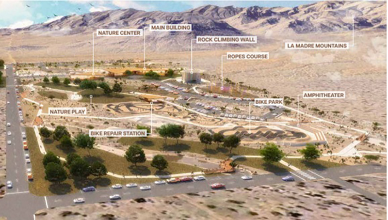
LaMadreFoothillsPark-Site_Map.jpgLaMadreFoothillsPark_site-rendering.jpg


THE FOOTHILLS

The plan calls for neighborhoods, parks and open space to embrace the land and surrounding foothills. This includes increasing tree canopy, preserving arroyos, preserving natural vistas and viewsheds, incorporating native and water-saving landscaping, and incorporating non-motorized routes. All development, rights-of-way, parks and neighborhoods in La Madre Foothills should minimize the spillover effects of nighttime lighting, incorporate appropriate use of signage that blends with the landscape, use ornamental fencing or native landscape in lieu of solid block walls, and incorporate drought tolerant native or adaptive landscaping to increases tree canopy coverage as approved under the city’s Urban Forestry Program and Southern Nevada Water Authority Regional Plant Standards.

NEIGHBORHOODS FOR CONVENIENCE

Because La Madre Foothills have lacked amenities for so long, the plan proposes land use types and recommended new uses and transitional densities west of I-215 with a focus on scaled mixed-use commercial activities at I-215 and the Ann Road/Hualapai Way interchanges. Placemaking is advised as well as minimizing the use of walls and fences that may reduce accessibility and neighborhood cohesion. Key portions of housing in the plan are policies for smart housing and neighborhood design, including a range of diverse housing types. Neighborhood design principles promote multimodal circulation, rear-loaded garages and alleys, bike parking, two-sided sidewalks, rear parking, provision of space for outdoor seating and on-street parking.

TRANSPORTATION/COMPLETE STREETS

The plan provides guidance on transportation to promote walkability and “streets for people,” employs traffic-calming strategies, provides a sensible street hierarchy, and prefers a traditional street grid to improve multimodal connectivity. The plan calls for improving transit access, supporting multimodal transportation electrification, and utilizing smart system approaches to making data-informed roadway and infrastructure design decisions. Reduced lanes of 10-11 feet result in consistently lower speeds, potentially saving lives, according to increasing evidence. Narrower lanes also provide more space for landscaping and biking and walking facilities. More walkable streets provide economic development opportunities for businesses fronting the roadway, defining community character and creating a sense of destination. The plan contains clear recommendations for the design and development of La Madre Foothills Parkway (proposed future name of Sheep Mountain Parkway) that will provide new north-south connections for all users.

INFRASTRUCTURE AND SERVICES

The city and its stakeholders should prepare for increased risk of extreme heat and natural disasters, such as flooding and earthquakes. In order to mitigate and respond to natural disasters, adequate facilities should be constructed to serve the growing population, such as a Las Vegas Metropolitan Police Department substation, more healthcare facilities and a new public safety complex. Through the planning process, it was determined that special improvement districts will be needed to pay for provision of water and probably drainage facilities. Like other areas in the northwest, La Madre Foothills lacks major facilities, such as libraries, community centers and schools; those may be required as population thresholds are met. While some private services are currently provided, there is a need for a greater presence of city services and community resources. La Madre Foothills has a shortage of all levels of public schools; new schools will be constructed over time and several will be under construction near-term to alleviate school overcrowding.

Connect with us

Subscribe and Follow

Sign up for the city newsletters and quickly get the latest information.

Sitemap

City Information

Copyright 2025 by city of Las Vegas